Showing posts with label Ordnance Survey. Show all posts

Saturday, 8 June 2019

Colouring London

Thanks to Steve Brace and Will Fry for the tipoff to this website.


I was due to be in London today at a GA committee meeting, but sadly had to wait in for the emergency plumber and drains person, so I'm doing a spot of colouring the city instead at Colouring London.
It's a map experiment, and another one created by the awesome folks at UCL CASA.

Colouring London is an open data platform being built and tested at University College London, and will launch formally in May 2019. It is designed to collect, collate, show and share statistical information about London's buildings, and become the first port of call for information on the city's fabric.
Colouring London is also a citizen science project
collecting data for scientific use, a free educational resource schools, and an initiative that celebrates London and our collective knowledge about it, and promotes sustainability and diversity within the city.
Looks like someone has already coloured in an important geographical landmark: the building in the centre of the image below.

Thursday, 11 October 2018

IAPS - GIS course

This course may be of interest to some readers of the blog.

IAPS Geography – Geographic Information System (GIS) for Prep Schools which is due to take place on Thursday 29 November 2018 at Abingdon School, Park Road, Abingdon, Oxfordshire OX14 1DE

The aim of this course is to make the purpose of GIS representation clearer for teaching Years 5, 6,7 and 8.  Delegates will discover how simple GIS skills will help prepare pupils moving to senior schools have the relevant skills.  Following an introduction to GIS, there will be practical sessions using the specialised computer room in Abingdon School’s Geography Department. 

Delegates will take away new ideas on how they can use GIS in their geography lessons and how mapping and the use of GIS can enhance their pupils’ geographical knowledge and understanding.

Full programme and map is attached for your information. 

For further details or to book online please visit https://iaps.uk/courses/detail/1341/

Friday, 11 January 2013

OS MapFinder App

A new app was launched on the iOS store today which a lot of people are going to find useful.
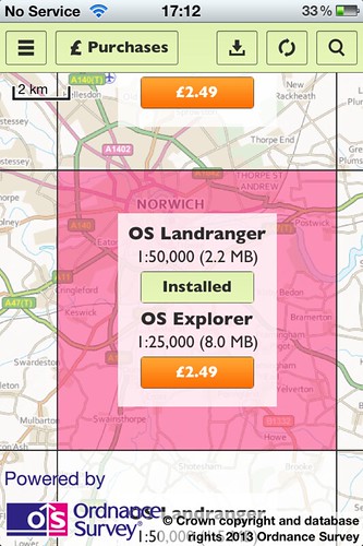
It's produced by the Ordnance Survey, and called OS MapFinder.

The app comes with a basic high level map of the whole country preloaded, as well as a sample map tile around Exeter - so the folks of Exeter get lucky :)
Further tiles can then be downloaded (for either 69p for 1:50 000 or £2.49 for 1:25 000) as an in-app purchase.

Map tiles can be explored, and routes can be added on and plotted. The app will also store routes which have been walked or cycled.
Places can be found using a search by postcode, name or grid reference.

If you want to see more about the app, there's a YouTube video below which shows you a lot more.


Wednesday, 28 October 2009

Language of Landscape Survey - prize draw

The Ordnance Survey Free Maps for 11 Year Olds are arriving in schools - you may already have had yours...
When you get the maps, you will also find a couple of (much sought after) hard copies of a publication called "The Language of Landscape"
The booklet is supported by a series of downloads from the NATURAL ENGLAND website.

I have created a SURVEY MONKEY SURVEY for those who have got their maps, and have also made use of the "Language of Landscape" to help students use the maps: whether inside or outside the classroom (or ideally both...)

Click Here to take survey

If you have used the maps and the book, please fill in the survey.

All completed questionnaires by 1st of December will be entered into a Prize Draw to win a copy of the KS3 Teachers Toolkit title: "Look at it this Way", a copy of the Geography Collective's "Journey Journal" and a few other geographical goodies....

Thursday, 10 September 2009

Language of Landscape

The Ordnance Survey are sending their free maps into schools once againthis term. Make sure you have registered to receive yours.
This year, in addition to the usual maps, stickers, map skills guide etc. there will be a 12 page booklet produced with Natural England.

Natural England website now has all the resources.
You can read about the scheme, and the booklet, which is called "The language of landscape" is available to download as a PDF.

The booklet is accompanied by a series of other PDF downloads to support the activities, which could contribute up to 4 lessons to a Year 7 Scheme of Work, such as these fab ACTIVITY CARDS (PDF download)Thanks to Mark Jones and Val Vannet, and also to Ian Gilbert for inspiration for part of this resource. Those credits didn't make it into the final document...

If you use this, please let me know what you thought of it, how it went, whether you invented some other activities etc.